Research
Laboratory of Geographical Information Sciences
This laboratory is going to study the natural environment as a whole which is composed of geomorphology, climate, hydrology, vegetation, and so on. Concretely, deductive approach and inductive approach are combined for conducting studies. The former approach is going to explain results from causes by physical lows such as mass balance, energy balance, equation of motion, and so on. The latter approach is going to explain facts demonstratively based on field surveys and in situ observations. Therefore, collection of quantitative data, digital mapping, statistical analyses, numerical modeling, and GIS (Geographical Information Systems) are main methods used in this laboratory.
The main study themes in this laboratory are listed as follows.
- Energy and water cycle in the atmosphere and hydrosphere
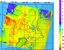
- Capturing snow distribution and snow water resources, along with snowmelt-runoff based on the remote sensing techniques and field surveys
- Quantitative evaluation of spectral reflectance characteristics of coniferous forests and their leaf area indices.
- Hydrological cycle around Mt. Aso and Tokyo metropolis
- Numerical simulation of urban climate
- Capturing surface conditions of cities using GIS
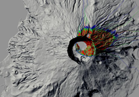
- Monitoring and modeling natural environment and natural hazards
![]()